
ধর্মতলা সন্ধানে
DHURRUMTOLLAH STREET Away From Durrumtollah
Dhurrumtollah Street, nicknamed ‘Dhurrumtollah ka Rasta’, is an approach road to Dhurrumtollah – a vaguely indicated locality north of village Chowringhee that anonymously spreads over the marshy terrain known as Colinga at one time. None of the old maps of Calcutta specifies the place of Dhurrumtollah, though the Dhurrumtollah Street invariably shows up in its place since Mark Wood’s map of 1784-85.
The Dhurrumtollah Street came up in around 1762, so did Jaun Bazar Road (later ‘Street’), both running eastward leaving Dingabhanga in between [Mark Wood, 1784]. Originally it was a causeway raised by deepening the ditch on either side of a land then owned by Jafer, a zamadar in the employ of Warren Hastings.”[Cotton]
COLINGA

Topography
It was the time when the English territory south of Town Calcutta was partly jungle, an extension of Sunderban, where Hastings said to have had the pleasure of tiger hunting.
Before coming of the English, Calcutta topography had been much simpler as Barrel’s 16th Century Bengal map reveals. The vast surrounding area, where the English later founded their first zamindari, looked like populated by only three distant villages – Chitpore, Kolikata, and Kalighat, connected by an unnamed jungle path. The 1680 map ‘Calcutta before the English’ adds few more names pointing to Sutanuti, Govindpore, Chowringhee, and also the Creek, and Jannagar at the eastern end.

The landscape in the vicinity of the Creek was then viewed as an extension of village Chowringhee – unworthy of any distinction. It was for the first time, the map Mark Wood prepared in 1784-85 charted the chunk of land separated from Chowringhee as Colinga. Colinga includes two subareas: Talpooker and Jala Colinga within its boundary. The two villages, Colinga, and Jala Colinga, however, were already enlisted in 1717, as ‘Colimba’ and ‘Jola Colimba’, among the 38 villages the English Company was permitted by the Emperor to buy. [Ray]
Talpooker was not in the buying list of villages. In Upjohn’s Mark Wood’s maps, Talpooker was prominently placed and it still exists as Taltola, an old quarter of metropolis, bearing one of the most common rural-names in Bengal, featuring habitations centred on ponds bordered with palm trees.
Jala Colinga is better known by its sobriquet ‘Dinga-bhanga’, which originated after the great 1737 cyclone that wrecked a dinga, i.e. large boat, on the swampy shoreline of the Creek – the vanished man-made canal for carrying cargo boats from Chandpal Ghat toward Beliaghata at the east end. [Blochmann]

The Creek was also referred to in Company documents as Calcutta khal. The vast territory extending from Calcutta Khal to the Tolly’s Nullah, covering the whole of the maidan spread a jungle tract of heavy undergrowth and giant trees. “This jungle was intersected by numerous creeks and watercourses, where the muddy yellow waters of the Hughly swept in with the rising tide or ebbed with the drainage of the surrounding rain-drenched country”. The old bed of the Creek remained, long after the closing of its connection with the river had deprived it of its stream, and turned it into a ditch. [Blechynden]
We normally accept unquestioningly whatever presented in a historical map, while the opposite may not be true in all cases. Whatever not presented, cannot be read as non-existent for sure since the possibility of their being existed namelessly can never be overruled without verifying the circumstantial evidence. Colinga is one of such cases. With all its parts: Talpooker and Jala Colinga appear separately in the list of 19 mauzas, and Dhee Calcutta, composed during 1767-1857.

Colinga and the newly enlisted villages were not expected to come up suddenly out of nothing. Normally, it takes ages for a geographic entity to acquire a name of its own, unlike the modern way of deciding street names on board meetings, as did the English Company in 1792. For a prolong period, when it remained essentially a part of village Chowringhee, Colinga had been a thinly populated uncultivated landscape occupying north-east segments with Dingabhanga and Talpooker on the peripheries.
Etemology
The name Colinga, assigned in Upjohn’s and Mark Wood’s maps, is a derived form of a rare Bengali word কলিম্বা (Colimba), has multiple meanings. It poses a serious challenge for us to distinguish between the etymological and the popular sense of the word in the current context. Vernacular lexicon shows 25 different sets of meanings, of which the followings are found plausible attributes contributing to the naming of the village Colimba (কলিম্বা), or Colinga:
(1) Trees: পাকুড় (Ficus religiosa, sacred fig) / শিরিষ (Lebbek Tree)/ কামরাঙ্গা (carambola) / তরমূজ (watermelon) (2) Terrain: marshland (হাজা। “হাজালে কলিঙ্গ দেশ”) (3) People: Kol tribe, a worshiper of Bonga (বঙ্গা) [Jnanendramohan]
On the basis of such semantic interpretations we may imagine how Colinga might have been before the increasing homesteads changed its ecology. Colinga and its surrounds, by lexical interpretation, apparently looked like a jungle of Sirish শিরিষ and Pakurh পাকুড় trees and a marshland (at Jala Colinga) with an abundance of kamranga কামরাঙ্গা vegetation; lived by Kol কোল and such tribal folks.

Ecology
The soil of Calcutta, marshy and damp, has always been displeasing, particularly in the rainy season, and more so because of the proximity of the river and a widespread lake – about 3 to 4 miles long and in no part above 18 inches deep, frequented by innumerable flocks of wild geese, duck, teals, etc. The site of Colinga was the nearest to that lake [Chattopadhyaya]


Colinga happened to be the last of the “typical swamp-type of vegetation including mangroves throve in and around Calcutta” for about 3000 years, as experts find. Perhaps, with the rise of land as a result of continued river silting and increased population the forest has since migrated southwards giving rise to the swampy forest of the present day Sunderbans. [Biswas]
Biodiversity
Since prehistoric eras the birds and animals travel Gangetic Bengal, migrate and settle colonies enriching natural resources contributing to improving quality of the soil and its landscape. As we all know, birds transport seeds and twigs from far and near across lands and oceans to germinate new variety of plant life, and they do it selectively by the atmospheric condition of a terrain. The birds living in and around Calcutta, and those visiting seasonally during the last two centuries, have been systematically recorded by birdwatchers. Frank Finn is one of them. His Birds of Calcutta is more relevant to our theme than elaborated work, Pet Birds of Bengal [Law]. We find 24 species of birds, all familiar to us but some like Paddy-bird – once so prevalent in the City of Palace, gone out of sight for good. Those are:
House Crow পাতি কাক, Oriental Magpie Robin দোয়েল, Seven Sisters ছাতারে, Bulbul বুলবুল, King-Crow দাঁড় কাক, Common Tailorbird টুনটুনি, Oriole, বেনে বউ common? Mynah ভাত শালিক, Dhtalধুলাল, Sparrow চড়াই, Honey-Sucker মৌটুসি, Woodpecker কাঠঠোকরা, Coppersmith Barbet বসন্তবাউরি, Blue-Jay নীলকণ্ঠ, Kingfisher মাছরাঙ্গা, Swift বাতাসি, Koel কোয়েল, Parrot তোতা Owl প্যাঁচা, Vulture শকুন, Kite চিল, Dove ঘুঘু, Gull গাং চিল, Paddy-Bird ধান পাখি।


 By Indian School, 19th Century; watercolour on paper;")

, by Shaikh Zain ud-Din for lady Mary Impey, Kolkata, India")

A cursory glance through the list may suggest that not all the species were fit for habitation in early Colinga environ. Flocks arrive at in stages with different compositions, adaptable for the ecological diversity, to contribute in transforming Colinga landscape from a marshland to cultivable woodland, orchard and paddy-field. There were no woodpeckers, honey-suckers at the beginning but gulls, kingfishers, snipes and the like. [Finn]

The landscape of Colinga before mid-18th century, so far we see, was much dissimilar to woody Govindpore, Birji and Chowinhee villages. Colinga remained a vast inhabitable wetland for centuries, infested with insects and aquatic creatures including water-birds. Initially, a number of coarse weeds began to invade the territory and a variety of thorny shrubs and other plants, not attractive to grazing animals advanced slowly, their seedlings sheltered by the weeds until large enough to escape the trampling. Eventually a thicket of small trees and shrubs appeared, of which, the commonest constituents should have been the thorny beri কুল, benchi বৈঁচি,and their near relative dumar ডুমুর,- a quick-growing, shrubby plant with coarsely hairy leaves, also arrived early on the scene.
Finally appear the large trees – the lofty palms তাল raise their crowns of fan-shaped leaves, mangoes আম, tamarind তেঁতুল and the lighter green of a neem নীম amidst them can probably be seen, and in the cold season – the naked branches of a simul শিমুল, or the spreading crown of a siris শিরিষ covered with yellowish pods stands out conspicuously from the green around them. There were some 69 trees only that Benthall considered naturalized in the neighbourhood of Calcutta, 41 were thought to be truly indigenous, 20 are natives of other parts of India, 6 originated in America, and 1 each in Africa and Malaya. On the other hand several plants, which seem to have been fairly common even in 19th century Calcutta have become scarce or lost forever, like Croton Tiglium Linn জায়ফল. [Benthall]


Benthall writes in early 20th century, “Not much more than a hundred years ago the wild rhinoceros roared near Alipore, and panthers were often hunted in what is now part of the city of Calcutta. In those days jungle must have stretched from the Sunderban to the edge of the city … Around Calcutta the country consists of treeless swamp and lake, and broad expanses of paddy-fields, interspersed with roads and paths and villages.” In such country, Benthall maintains, wasteland suitable for the growth of trees and shrubs is scarce, but here and there patches may be found which for some reason or other are neither cultivated nor planted with useful trees. [Benthall]

Colinga was certainly one such place of marshy land that remained till recent time uncultivated, in an atmosphere totally different from the then Kalighat, Govindpore, Calcutta areas. It was then wild marshy woodland lived by tribal in hutments making minimal anthropogenic hazards barring the manmade canal created for navigation by the early village dwellers. The scenario discourages us to believe of a presence of grand shrine revered by people of all faiths as a holly place. If at all any such generally acceptable shrine erected as a place of dharma (ধর্ম), it must have been created long after, but not later than, 1764 when ‘Dhurrumtollah ka Rasta’ was rolled over a muddy beaten track that supposed to lead to the holy place.
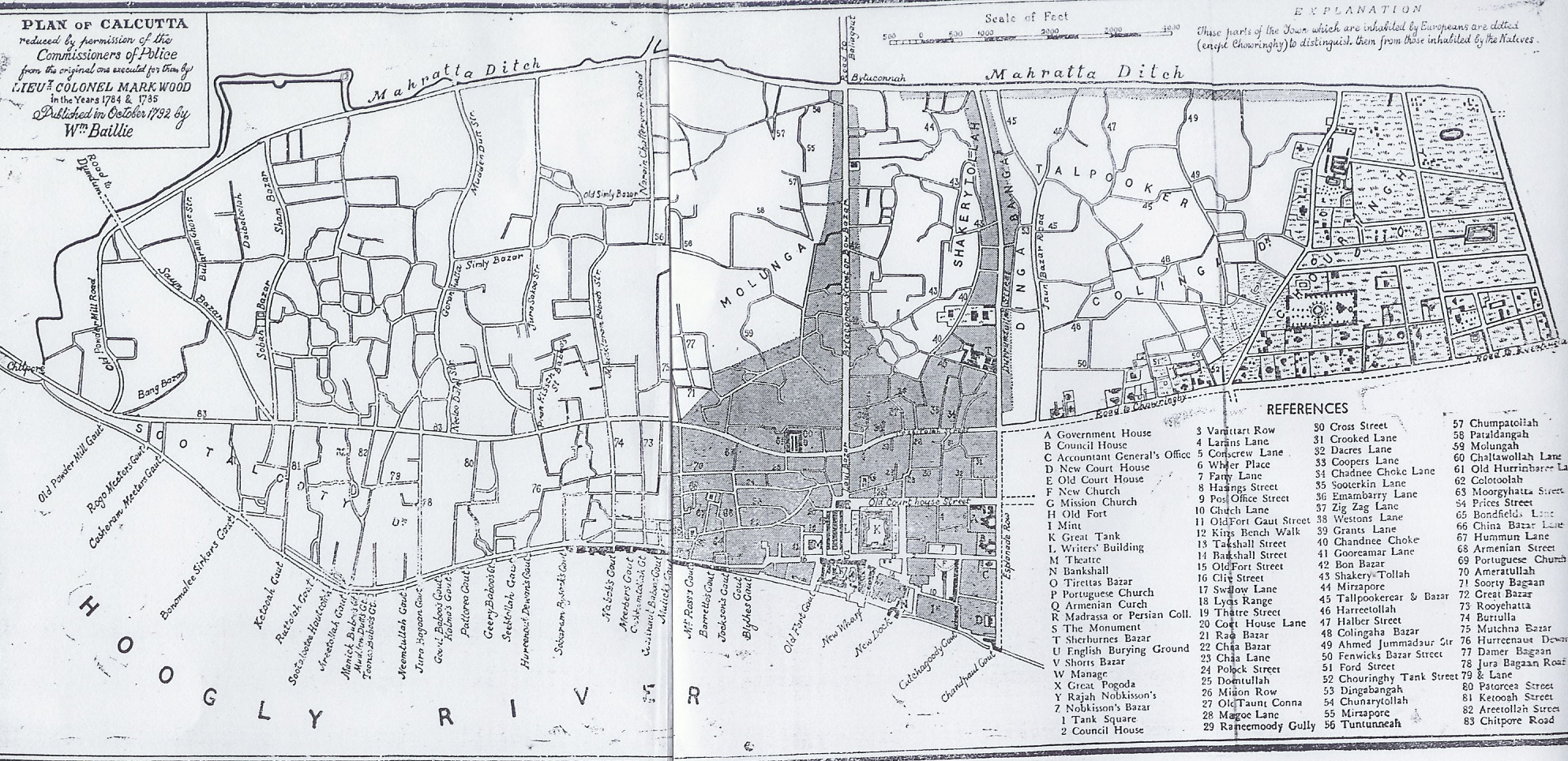
Modern Scenario
The reconstructed view of the expansive area of Colinga, earlier a part of the forested Chowringhee for about three centuries, may prove to be a rude contrast of what we see in the colonial paintings and photographs documented by the contemporary artists and lens men. Upjohn’s 1793 map gives an idea of the expansion by marking the site of Colinga Bazar Street, and of the Colinga Tank. Colinga Bazar Street stood at the south of Jaunbazar Street, and Colinga Tank, later Monohur Doss Tank, was shown on Maidan opposite the house of Messers Stone and Hoffmann. In Bailie’s map of 1792 Chowringhee contains 45 houses and plenty of paddy-fields. Europeans have moved eastwards and southwards to Bow Bazar Street and Circular Road, while Taltola, Colinga, and Fenwick Bazar are inhabited by native Indians. [Ray] During the end of the 18th century, Europeans came to stay here. The Bengal Gazette editor, James Augustus Hickey, Justice Le Maitre resided in this neighborhood. Since mid-19th century the Colinga Street became an infamous locality of European and Eurasian harlots.
In a Calcutta Municipal Corporation meeting of 17 July 1912, the previous name ‘Collingabazar Street’ was changed into ‘Collin Street’. By dropping the last two letters from its name,‘Collinga’, a variant of ‘Colinga’, turned into ‘Collin’, which the commissioners found necessary to make the Street sound more respectable and attractive to the prospective buyers of lands and houses. Following the decision, not the street alone but everything else known by its name got changed. Colinga was erased from Calcutta map and collective mind of the people, leaving Dhurrumtollah homeless, faceless unidentified geographic entity.

There is perhaps another way of finding Dhurrumtollah by applying our mind more toward human elements than to the physical elements of issues. So far we attempted to understand the natural condition of the venue, now let us question how the human folks lived there when Colinga became habitable. We knew that on the plains of Bengal, two trees, peepul(অশ্বথ) and banyan(বট) tend to dominate all others, and Colinga might not be an exception. We may question now why the two are called sacred fig-trees, and try to examine how far Bentham was correct when he said, “Both these trees are venerated by the Hindus and are often planted for religious reasons near houses and temples and in villages. Beneath their branches may be seen little shrines marked by the presence of rounded stones, and sometimes small temples are erected in their shade” (my emphasis). [Benthal]
Endnote
The scenario reminds us of the beaten jungle path of pre-colonial days leading to a widely acknowledged dhurrumtollah, or ‘divine place’, where worshipers arrive from distant villages taking the eastward route that the present Dhurrumtollah Street follows. This street may not lead to a locality ‘Dhurrumtollah’ as the Chowringhee Road and Jaunbazar Street did – one to locality Chowringhee, the other to Jannagar. Instead, it can be in all probability a sacred location and not a locality. Before exploring new directions, it is important to settle a few questions bothering our focus. Should this dhurrumtollah necessarily be an outstanding devotional edifice like temple, mosque or a church? If yes, its location must have been somewhere off the street and not on the street or its sides. Secondly, how far realistically we can think of such an architecture erected before 1764 – the year Dhurrumtollah Street constructed?
I would like to take up these questions in my next post: THE HOLLY STREET DHURRUMTOLLAH
REFERENCE
Books
- Bagchi, P.C. 1938. The Second City of the Empire. Calcutta: Indian Science Congress Assoc.
- Benthall, A. P. 1933. Tree’s of Calcutta and Its Neighbourhood. Calcutta: Thacker, Spink. Retrieved (https://archive.org/details/TheTreesOfCalcutta).
- Biswas, Oneil. 1992. Calmtta and Calcuttans From Dihi to Megalopolis. Calcutta: Firma KL. Retrieved (https://archive.org/details/in.ernet.dli.2015.149376).
- Blochmann,H. 1978 ‘Calcutta during the Last Century’ in Alok Ray edt. ‘Calcutta Keepsake’, Calcutta: Rddhi-lndia. (https://www.amazon.com/marsh-township-east-Calcutta-Department/dp/8170740738)
- Cotton, Evan. 1907. Calcutta, Old and New: A Historical and Descriptive Handbook to the City. Calcutta: Newman. Retrieved (https://archive.org/details/calcuttaoldandn00cottgoog).
- Chattopadhyaya, Haraprasad. 1990. From marsh to township east of Calcutta: A tale of Salt Water Lake and Salt Lake Township. (Department of History, University of Calcutta, monograph) (https://www.amazon.com/marsh-township-east-Calcutta-Department/dp/8170740738)
- Frank Finn. 1904. Birds of Calcutta. 2nd ed. Calcutta: Thacker, Spink. Retrieved (https://archive.org/details/birdsofcalcutta00finnrich).
- Kathleen Blechynden. 1905. Calcutta: Past and Present. London: Thacker. Retrieved (https://archive.org/details/calcuttapastand02blecgoog).
- Law, Satya Churn. 1923. Pet Birds of Bengal; v.1. Calcutta: Thacker, Spink. Retrieved (https://archive.org/details/petbirdsofbengal00laws).
- Ray, A. K. 1902. Calcutta: Town and Suburbs; Pt.1 A Short History of Calcutta. Calcutta: Bengal Secretariat. Retrieved (https://books.google.co.in/books?id=-Lo5AQAAMAAJ&q=calcutta+town+and+suburbs+ak+Ray&dq=calcutta+town+and+suburbs+ak+Ray&hl=en&sa=X&ved=0ahUKEwjDnrz11MnXAhUCN48KHdgEDQUQ6AEIJzAA).
- Wilson, Charles R. 1895. The Early Annals of the English in Bengal; Summarised, Extracted, and Edited with Introductions and Illustrative Addenda; Vol.1. London, Calcutta: Thacker. Retrieved (https://archive.org/details/earlyannalsofeng01wilsuoft).
- জ্ঞানেন্দ্রমোহন দাস. n.d. বাংলাভাষার অভিধান. Retrieved (https://archive.org/details/bub_man_c3ef006702a4d6c876970cc35b669346).
Maps and Plans
- Bengal. 1550. River: From Hughli to Sea in the 16th century; according to Joao de Barrel and the Bengali poets. [Reprinted See: Wilson. page 129]
- Calcutta. 1680. Calcutta before the English [map] [Reprinted See: Wilson. page 126]
- Calcutta. 1792 & 1793. Map of Calcutta and its environs; by A Upjohn (http://www.museumsofindia.gov.in/repository/record/vmh_kol-R565-C1737-2914)
- Calcutta. 1792-93 Map of Calcutta and its environs From the accurate survey taken in the year 1792 & 1793 by A Upjohnhttp://www.museumsofindia.gov.in/repository/record/vmh_kol-R565-C1737-2914
Calcutta. 1793. Plan of Calcutta; reduced by permission of the Commissioners of Police from the original one executed for them by Lietn Colonel Mark Wood of 1784-1785. Published in October 1792 by William Baillie. https://upload.wikimedia.org/wikipedia/commons/8/82/Kolkata_Old_Map.jpg - Calcutta. 1847-49. Map of Calcutta from actual survey. Contributors: Simms, Thillier, and Smyth. London: Chapman, 1858 (https://www.loc.gov/resource/g7654c.ct001429/?r=0.604,0.19,0.07,0.03,0)


Dear ” Ajantrik”– your latest article on — Dharamtolla Street – (no less than Londoner’s Piccadilly to me) — came as a welcome ancestral jewel box — rekindling fading memories and stories — once heard about this arterial road in my childhood Calcutta life — from ancestors , departed long ago. If I remember correctly — some time in late ’40s of last century I had the privilege to go through a voluminous book on the city named — ?KALIKATHER KATHA by Late Promothonath Mullick in his palacial residence near Shyambazar Tram Depot – whose close relation Nitai Chand Mullick being my erstwhile school classmate. That was quite informative but your write ups surpass every book on Kolkata that I have read uptil now . Amazingly well researched to the finest possible detail. My grandmother (Didima ) used to tell that when her mother — who was married into a renowned Kaviraj ( Boidya) family in Colootola are — used to visit her parents in Bhawanipur area in PALKI accompanied by a bevy of Paiks as guards — crossing the stretch of sparsely populated area from Dharamtolla Street to the border of Bhawanipur was a bit scary even in late 19th. Century. Can you throw some light on Bowbazar as to who founded this market? With regards — N.K.Majumder from Pondicherry.
LikeLike
Many thanks Nirmalay. I have no luck as yet to read Kolikatar Katha of Pramothanath Mullick. Hope, like other celebrated vernacular works on old Kolkata it will be made available on line before too long. Yes, so far I gather, Dhurrumtollah was like that in your Didima’s time. The bazar in the Bowbazar locality was said to be owned by Biswanath Matilal’s family, and named after one of their daughter-in-laws (বউ) to whom the property was said to have fallen. AK Ray (Calcutta, Census 1901) on the contrary maintains that Bowbazar, a corruption of ‘বহু বাজার’, is a locality where a number of petty bazars were held. Personally, I think ‘বহু’ is not a colloquial expression, nor ‘bow’ a likely transliteration of Bengali ‘‘বহু’.
Warm regards and wishes
LikeLike
Sir , ” My grandmother (Didima ) used to tell that when her mother — who was married into a renowned Kaviraj ( Boidya) family in Colootola are — used to visit her parents in Bhawanipur area in PALKI accompanied by a bevy of Paiks as guards ” – Who is your grandma ?
LikeLike
Dear author, It’s been an extravaganza. Waiting for the remaining part.
Thanking you, With best regards,
Hirak Chatterjee Research Scholar
C/O Dr. Sujit Kumar Ghosh Department of Chemistry Assam University Silchar-788011 Assam, INDIA
Contact No: +918486882543 (ASSAM) +919475265107 (WEST BENGAL)
LikeLike
Thanks Hirak. I feel good when young scholars like you find puronokolkata stories interesting. I intend to cover more facets of Dhurrumtollah. The next one, Holy Dhurrumtollah may take around two months to reach your hand. Wishing you best
LikeLike