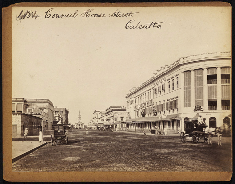
পুরনো কোর্ট হাউস স্ট্রিটের দৃশ্য (ছবিতে উল্লিখিত কাউনসিল হাউস রোড সংকেতটি বিভ্রান্তিকর) , কলকাতা, c১৮৫০
The view was incorrectly captioned in the original as Council House Street instead of Old Court House Street as evident from the description. Old Court House Street connects Esplanade Row (East). It acquired its name from the old court house, that was located where St. John’s Church now stands. The northern part of the stretch is known as Dalhousie Square (East). It was constructed around 1781, when the finishing touches were put to the new Fort William. It is linked with the name of Col. Henry Watson, who brought about many improvements in Calcutta, including the laying out of surrounding Esplanade. The Red Road is an extension of this street. Council House Street connects the western part of Dalhousie Square with Esplanade Row. The view of the St. Andrews Kirk, and Great Eastern Hotel can be seen in the present location. Interestingly, the scene captured in the shot is found an exact match in ‘Old Court House Street‘ – a wood engraving by some unidentified artist.
This image is a whole-plate albumen print from wet collodion glass negative of photograph taken by Frith Frith in 1850s.
Discover more from PURONOKOLKATA
Subscribe to get the latest posts sent to your email.


Pardon Me, But I think you intended to mention St. Andrew’s Kirk in place of St. John’s Church.
LikeLike
An awful slip, indeed. Thank you so much, Amitabhababu for the correction. Warm wishes
LikeLike
Pardon me, but I think you meant to say St. Andrews Kirk instead of St. John’s Church.
LikeLike
An awful slip, indeed. Thank you so much Amitabhababu for the correction. Warm wishes
LikeLike